
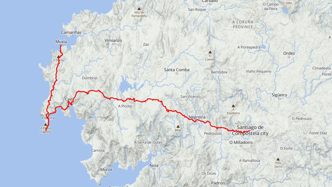
Later this year, I’ll be walking a Camino route that begins where the land meets the Atlantic: Muxía to Finisterre and then to Santiago de Compostela. Some pilgrims end their Camino at the cathedral and then continue on to the coast, but I’m choosing to begin at the edge of the world (Finis Terrae to the Romans) and walk a rural inland route back towards Santiago.
When I first began planning my Camino, I knew I wanted a quiet journey… an opportunity to walk along northern coast of Spain and settle into my own rhythm on the trail. Starting in Muxía at the Atlantic’s edge feels like the right way to do that. I am hoping this route brings both the quiet and the coastal experience I am hoping for.
I have intentionally stretched out my route so there is room to explore, linger, and let the journey unfold. Rather than grinding through long stages, I have broken my walk into smaller pieces that will allow me to slow down, reflect, and soak in Galicia’s landscapes at a comfortable pace.
Here is a quick breakdown of the the stages for my Camino. The noted distances do not include some of the detours I might choose to do along the way. Only time will tell how how that plays out…
Stage 1: Muxía to Lires
Distance: 14.2km
A coastal start that will take me past the Sanctuary of A Barca and into the countryside. With gentle terrain and open views, it’s a short day meant to help me settle into my stride.
What is the Sanctuary of A Barca? It’s a centuries‑old coastal shrine in Muxía dedicated to the Virgin Mary, built right on the rocks where the Atlantic crashes into the shoreline. According to tradition, the Virgin Mary arrived in Muxía in a stone boat to encourage St. James in his mission. The “boat” is said to still be there in the form of three massive stones. These stones were sacred long before Christianity, tied to Celtic rituals, and later woven into Christian lore. Based on some of my research, it is one of the most spiritual sites in Galicia.
There are a number of potential detours that I am considering on this stage including Monte Facho (high viewpoint over the entire Muxía peninsula), rugged coastline, and some beautiful beaches near Lires.
Stage 2: Lires to Finisterre
Distance: 19.5km
A beautiful coastal stretch leading toward Finisterre and its dramatic peninsula. I’m giving myself extra time in Finisterre to explore the lighthouse, the beaches, and the feeling of standing at the old “end of the world.”
A few notable things I am hoping to check out here:
- Praia de Langosteira: A long, sweeping beach just outside Finisterre. It is supposed to be one of the most iconic beaches on the Camino.
- The “0.0 km” marker: The Camino’s symbolic endpoint sits near the lighthouse and even though I am walking the route in reverse, it will be neat to check out as a reminder how many journeys have ended here.
- The lighthouse and cliffs: The Faro de Fisterra is supposed to be super dramatic with steep cliffs, crashing waves, giving one the sense of standing at the edge of the world.
Stage 3: Finisterre to Cee
Distance: 12.5km
A short coastal day that will give me a final look back at the Finisterre lighthouse before rounding the estuary toward Cee.
My walk will take me through Corcubión, a small historic fishing town with stone houses and a quiet waterfront, before continuing on to Cee.
Cee is also supposed to be quite relaxed with a working-port atmosphere and a lively waterfront. Hopefully a good stop to load up on any supplies I might need before beginning my trek inland through some more rural areas.
Stage 4: Cee to Olveiroa
Distance: 22.3km
The trail will climb inland from Cee, trading coastline for rolling hills and green farmland. Small hamlets and shaded paths lead toward Olveiroa, which looks to be a nice peaceful village set deep in rural Galicia.
I hope to check out some hórreos (stone granaries) along the way. An hórreo is a raised stone or wooden structure that are used for storing corn and grain. It’s built on pillars with flat “mushroom‑shaped” stones (called tornarratos) that keep rodents from climbing up. The slatted walls allow air to circulate so the harvest dries without rotting.
I’ve read that many of the buildings in Olveiroa are centuries old and have been restored in traditional style. I am hoping this might end up being a very memorable inland village stop on my route.
It would be a fairly long detour (>10km) but from what I’ve read, Mirador de Ézaro (waterfall) might be worth the extra effort.
Stage 5: Olveiroa to Vilasereio
Distance: 18.9km
A rural, reflective stretch through tiny villages and forest paths. This is a pretty rural area and should be one of the quieter parts of the Camino.
In addition to more hórreos, I’ve read that there are quite a few ancient springs along this section that it on sites that were considered sacred in pre‑Christian Galicia.
I am also hoping to come across some cruceiros which are stone crosses that mark crossroads, village entrances, churchyards, or important points along old routes. These crosses are Christian replacements of ancient (pagan and Roman) boundary stones that were likely at some of these locations. Before Christianity, crossroads were often considered places where the physical and spiritual worlds overlapped. In my research, I even stumbled across a pretty cool project to build a comprehensive inventory of the cruceiros.
Parts of this route follow old Roman and medieval paths once used to move livestock and goods. As we’ve travelled through Europe on other trips, it’s always humbling to walk in the footsteps of people from another age… in a world that was so different than the one we live in today.
Stage 6: Vilasereio to Negreira
Distance: 14.1km
This should be another calm inland day that will take me through a number of hamlets, farmland, and eucalyptus groves. As I get closer to Negreira, it will inevitably get busier and I look forward to exploring the town before my final stage that will have me arrive in Santiago.
I hope to be able to explore a number of old stone bridges and mills along the way… some of which date back to medieval times and may also have roots back to the Romans.
As I make my way into Negreira, I might also check out Pazo de Cotón which is a fortified 17th‑century manor house.
Stage 7: Negreira → Santiago de Compostela
Distance: 21.3km
The final approach.
On this final stage, I’ll make my way through a number of old stone villages and forest groves on my way to Praza do Obradoiro… the historic square where pilgrims have arrived for centuries.
I have read that the moment the cathedral towers appear before you is something every pilgrim remembers. I’m giving myself an extra day to explore Santiago and the reflect on the completion of my journey.
I don’t know exactly what unexpected twists and turns this walk will offer, but that’s part of the appeal. I’m ready to step into it and see what the Camino has in store for me.


You must be logged in to post a comment.